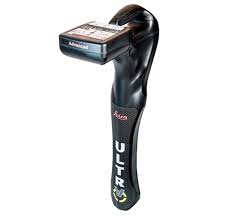
Leica Ultra Advanced Receiver
The Leica ULTRA Advanced Receiver is a high-precision utility tracing instrument designed to accurately locate and trace underground utilities. It integrates intelligent signal processing with flexible operating modes, enhancing efficiency and confidence in utility detection tasks.
Key Features:
• Ambient Interference Measurement (AIM): Analyzes surrounding noise and recommends optimal frequencies for accurate tracing in congested environments.
• Offset Measuring: Enables location of utilities that are not directly accessible from above by estimating horizontal and vertical distances.
• Transmitter to Receiver Link: Allows remote control of the transmitter directly from the receiver, reducing the need to physically access the transmitter during operations.
• Customizable Frequencies: Offers over 100 preselected frequencies and the option to customize frequencies for specialized applications, optimizing performance for specific site conditions.
• Bluetooth Connectivity: Enables wireless communication with GIS field PCs or GNSS receivers, facilitating seamless data integration and mapping.
Specifications:
• Frequency Range: 50 Hz to 200 kHz
• Maximum Depth: 6 meters (20 feet)
• Locate Accuracy: ±5% of depth
• Environmental Protection: IP65 rating, ensuring durability against dust and water ingress
The Leica ULTRA Advanced Receiver is an essential tool for professionals requiring precise and efficient utility location capabilities, offering advanced features to tackle complex underground environments.