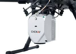
CHCNAV AlphaAir Mobile Mapping Unit
The CHCNAV AlphaAir Mobile Mapping Unit is a cutting-edge solution designed for construction and surveying professionals who require comprehensive and efficient data collection in various environments. This mobile mapping system integrates advanced imaging and LiDAR technology to deliver high-resolution 3D data, allowing for precise mapping and analysis of complex terrains and urban landscapes.
Engineered for versatility, the AlphaAir unit can be mounted on vehicles, enabling seamless data capture while in motion. This mobility significantly enhances productivity, reducing the time needed for site surveys and allowing for the efficient collection of extensive geographic information. The system features user-friendly software that streamlines data processing and visualization, transforming raw data into actionable insights with ease.
Whether you're involved in infrastructure development, land surveying, or environmental assessments, the CHCNAV AlphaAir Mobile Mapping Unit provides the accuracy and efficiency necessary for informed decision-making. Equip your team with this state-of-the-art mapping solution to elevate your project outcomes and enhance operational capabilities across all phases of construction and surveying.