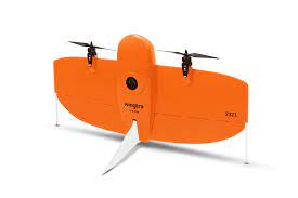
WingtraOne, Gen II
The WingtraOne GEN II is a high-precision vertical take-off and landing (VTOL) drone designed for surveying and mapping applications. It offers exceptional accuracy, extensive coverage, and versatile payload options to meet diverse project requirements.
Key Features:
• High Accuracy: Achieves absolute horizontal accuracy down to 1 cm (0.4 inches) and vertical accuracy up to 3 cm (1.2 inches) without the need for ground control points (GCPs).
• Extended Flight Time: Capable of flying up to 59 minutes per flight, allowing for comprehensive data collection over large areas.
• Significant Coverage: Can cover up to 315 hectares (780 acres) in a single flight at a ground sampling distance (GSD) of 2 cm/px (0.8 in/px).
• Versatile Payloads: Supports various payloads, including high-resolution RGB cameras like the Sony RX1R II and multispectral sensors such as the MicaSense RedEdge-P, catering to different surveying needs.
• Robust Performance: Operates effectively in sustained winds up to 12 m/s (27 mph) and wind gusts up to 18 m/s (40 mph), ensuring reliability in diverse environmental conditions.
• User-Friendly Operation: Equipped with the WingtraPilot flight planning software, facilitating intuitive mission planning and execution.
The WingtraOne GEN II is an ideal solution for professionals seeking efficient and accurate aerial data collection across various industries, including construction, agriculture, and environmental monitoring.